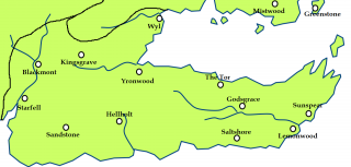
File: Dorne.png
From A Wiki of Ice and Fire

Size of this preview: 800 × 383 pixels. Other resolutions: 320 × 153 pixels | 1,385 × 663 pixels.
Original file (1,385 × 663 pixels, file size: 118 KB, MIME type: image/png)
Created by Scafloc from a map of Westeros on wikipedia[1].
![[1]](http://en.wikipedia.org/wiki/File:Westeros.png)
As the orginal wiki map: permission is granted to copy, distribute and/or modify this document under the terms of the GNU Free Documentation License, Version 1.2 or any later version published by the Free Software Foundation; with no Invariant Sections, no Front-Cover Texts, and no Back-Cover Texts.
A copy of the license is included in the section entitled "GNU Free Documentation License"[2].
File history
Click on a date/time to view the file as it appeared at that time.
| Date/Time | Thumbnail | Dimensions | User | Comment | |
|---|---|---|---|---|---|
| current | 15:09, 17 March 2011 | | 1,385 × 663 (118 KB) | Scafloc (talk | contribs) | Created by Scafloc from a map of Westeros on wikipedia[http://en.wikipedia.org/wiki/File:Westeros.png]. As the orginal wiki map: permission is granted to copy, distribute and/or modify this document under the terms of the [http://en |
- You cannot overwrite this file.
File usage
The following 43 pages link to this file:
- Blackmont
- Boneway
- Brimstone
- Broken Arm
- Dorne
- Ghaston Grey
- Ghost Hill
- Godsgrace
- Greenblood
- Hellholt
- High Hermitage
- Kingsgrave
- Knight of Lemonwood
- Lemonwood
- Lord of Blackmont
- Lord of Ghost Hill
- Lord of Godsgrace
- Lord of Hellholt
- Lord of Kingsgrave
- Lord of Salt Shore
- Lord of Sandstone
- Lord of Yronwood
- Lord of the Tor
- Planky Town
- Prince's Pass
- Red Mountains
- Salt Shore
- Sandstone
- Scourge
- Sea of Dorne
- Skyreach
- Starfall
- Sunspear
- Tor
- Torentine
- Vaith
- Vaith (river)
- Vulture's Roost
- Water Gardens
- Wyl (castle)
- Wyl (river)
- Yronwood
- User:SerMyLady/Maps